Sunday, August 4, 2013

Home Again, Home Again....


Tuesday 23 July – The starter/solenoid was ready for pickup at 1015, so with that all fixed up, Linda and I picked up Gary (and his wife, Wendy) and we drove up Vancouver Island to Port Hardy, arriving at 1400. While the others did a bit of restocking shopping, I reinstalled the starter, now working well. We had an early dinner at the Quarterdeck Pub, then Linda and Wendy drove home to the Comox Valley, while Gary and myself watched a movie (“The Lone Ranger”), then had an early night.

Wednesday 24 July – We were up by 0700, had a quick cereal breakfast, settled accounts with the marina, and then moved over to the fuel dock to top up the diesel. By 1015 we were underway under overcast skies and fog, and a light northwesterly wind. By 1120 the fog was starting to lift as we passed by the Masterman Islands, turning Southeastbound.. At 1230 we were still passing into occasional fog banks, in light and variable winds, now motoring past Pultenay Point on Malcolm Island....at least we were getting a 2 knot push from the flood tide. It seemed a bit early to put in for the day, so we continued past Port MacNeil in Broughton Strait, now in clear skies. As we motorsailed past Alert Bay at 1345, I radioed to Telegraph Cove, who had a slip available....and by 1430 we were tied to the docks at Telegraph Cove enjoying the fine summer weather. We walked the boardwalks and admired some of the fine-looking salmon being landed here. We visited the whale museum, which has several full skeletal remains of various types of whales....then had a beer at the pub before returning to the boat for dinner. The marina here has very nice shower facilities, so we took advantage of these, as well.

Thursday 25 July – At 0800 when we arose, the overnight fog was just lifting to a beautiful sunny day with moderate northwest winds. We topped up the water tanks and by 1030 were underway into Johnstone Strait. The wind and tide were both cooperating, and we had a beautiful sail downwind. By 1500 the wind was increasing as we passed by Havannah Channel, and the tide was still with us. We reefed the sails and kept on. By 1700 we were off Sunderland Channel and approaching Kelsey Bay, in a still-strengthening wind, and with the seas becoming a bit more unruly. Even with our reefed sails, the wind was now gale force....so we turned up Sunderland Channel and had an exhilarating run down the Channel the 6 miles to Forward Harbour. By 1830 we were anchored in quiet waters in 55 feet of water, and barbecued some steak for dinner. Time for another movie (“Les Miserables”) on our chart plotter cum entertainment centre, before retiring atg 2230.

Friday 26 July – The strong northwest winds were continuing in Johnstone Strait, according to the forecast, but using the inside route we should get the same direction, but not as much force.....so we had blueberry pancakes for breakfast, and waited for the tide. By 1100 we had the anchor up, and the ebb tide was slacking off. As we exited the inlet the overcast skies became sunny and clear, with a nice northwesterly wind of 15 knots. We were able to motorsail through Whirlpool Rapids 45 minutes before the slack tide, and continue on a broad reach past Loughborough Inlet and through Greenpoint Rapids, with the wind picking up to 20 knots and allowing us a very nice sail. By 1430 we were approaching Shoal Bay and entered the bay looking for a tie-up or anchorage....but lots of boats were hunkered down here, with no room on the docks or in any safe anchorage spots. So we continued into Frederick Sound (another couple of miles). Several years ago I'd stayed at Oleo's Gallery, a restaurant with docks and a float-home. It was still there, but Ruth, the owner/proprietor, or her son, were not there. We tied up and made friends with the dog, hoping they'd come back later in the afternoon....but it was just us, the dog, and a cat. At 1830 I pulled some stuffed chicken breasts out of the freezer and made up a dinner, and we relaxed on the boat while the wind howled outside the little protected bay we were tied up in. We watched another movie (“Django Unchained”), and with no sign of anyone arriving to allow us to stay or boot us off, we settled down to a peaceful night.

Saturday 27 July – Although we'd sailed through Whirlpool and Greenpoint Rapids near, but not at slack tide, we were intent on clearing our next tidal rapids, Dent and Yuculta Rapids, as close to slack as possible. So we were up at 0630 and underway at 0715. Fifteen minutes later, our engine was overheating. By now I had lots of experience clearing this type of problem, and discovered a wad of eelgrass in the intake, and had it cleared fairly quickly, as we sailed along in 20 knots of northwesterly breeze. At 0815 we were sailing through the Dent Rapids with a 2 knot push, and reached the Yuculta Rapids 20 minutes ahead of slack water, at 0830. We then had a very pleasant sail past Calm Channel and into Sutil Channel, and with the wind picking up, had to put a reef in the sails, while we continued to sail at over 8 knots. By the time we were sailing past the south end of Reid Island, we were on a close reach, heading into Herriot Bay in Northerly 30 to 35 knots of wind......but we were tied to the docks at the Herriot Bay Inn by 1300, with time for a beer and lunch, showers, and a short walk up the hill to the grocery store for fresh vegetables for dinner. Although cellular coverage is poor in this area, a kind fellow at the grocery store drove us to the top of a hill to call home, as the plans were to continue home to Comox in the morning. We cooked up a pork tenderloin dinner, and then went to the pub for our last night out on the boat. The people of Quadra Island/Herriot Bay know how to party hardy. The pub had a jam session with local groups or entertainers invited to perform, and the entertainment included several rock groups, a country group, a piper on bagpipes, a standup comic, a fiddler, a harmonica player....a bit of everything. One group in particular caught our fancy – a bluesy, folksy music group named “Brodie Dawson and Friends”. They hail from Campbell River, and both Gary and I will be watching for them again, as they were extremely talented and entertaining. It turned out to be a late night (for us), as we didn't get to bed until well after midnight.

Sunday 28 July – In spite of the late night we were up at 0730. The skies were clear, and the wind forecast for a pleasant Northwest 15 knots – perfect for a run back to Comox. We couldn't leave the docks right away, as several other boats further out on the docks needed to get away first, before we'd fit out the slot between the docks. In walking around these docks, I was mortified by the condition of them, with the pilings supporting them being extremely eroded, and only tied on with a piece of line (not ever really tied – the “knot” was only a half-hitch!). I couldn't believe the docks had held together with all of the boats tied to them, through the strong and near-gale force winds we'd just had.
This is how the docks are tied to the pilings

The pilings at the docks at Herriot Bay are a bit "iffy"

 At any rate, we got underway by 0930, and an hour later we were off Francisco Point, at the south end of Quadra Island, in calm and clear weather. Wind continued to elude us as we motored southbound past Mitlenatch Island. We had a go at trolling for salmon as we passed Sentry Shoal and then a shallow area opposite Gary's home, called “The Hump”. Alas, we had very little luck here, with only a very small Coho Salmon which was returned to the sea to grow up.
Gary's big Salmon Catch

Still without wind, or fish, we motored on into Comox, arriving at our home port at 1730, to be met by Linda and Wendy, our wives. Now to clean up the boat and get ready for the next adventure!

Monday, July 22, 2013

Go West - If you Can!

Mon. 15 July – We'd talked with Jim and Barb on “Berkana” about visiting Anthony Island, aka Ninstints or S'Gang Gwaii. This is a UNESCO World Heritage Site, and the most preserved of the Haida Cultural visiting sites. The preferred anchorage is on the north side of the island, surrounded by rocks, and with forecast Northwest winds of 20+ knots, could be a bit dicey for a visit, as it would be impossible to see the boat at anchor (or not, if it's dragging anchor), while at the site. They were inclined to hire a zodiac from Rose Harbour in a tour group, but we opted instead to go as a group of 4 in one of our boats, and if it was rough, two people at a time could visit the site and two mind the boat. We ended up taking Jade-1, and were underway at 0845 with Jim and Barb onboard with us. We got a nice 2 to 3 knot current push out Houston-Stewart Channel, with clear skies and a 15 knot northwest wind. At 1100 we were off the northeast side of S'Gang Gwaii, and contacted the watchmen on the radio. They advised that the mooring buoy on the north side of the island had gone adrift, so we'd have to anchor there, or we could take a mooring buoy on the east side of the island (a secondary bay which was also on the leeward, protected side of the island). We chose the east bay, and were tied in a calm cove to a secure mooring buoy at 1120. We rowed the dinghy ashore with all four of us (it was a safe, secure spot), and were met by our guide/watchman, Ken Haas. Here we saw lines of poles and were treated to a very informative tour by Ken, who had studied fine arts, was himself a native carver and artist, and thus was able to explain much of the detail in the pole carvings, as well as some of the legends and stories that go with these carvings. Most of the poles remaining here are mortuary poles – the Haida equivalent of gravestone markers. The other, ceremonial, house frontal, and decorative poles have mostly been removed by museums around the world. Ken was also able to point out several longhouse foundations, with the tenon joints in the support beams still visible. At this site, as at the others, the poles and village remains are being allowed to return to nature. But here, they have been removing some of the moss as it grows, to slow down the decay a bit – they can't use any preservatives, and when things come apart they are left to return to nature – but they have managed to at least still have some very impressive carvings and works which an interested noviice like myself can still appreciate (I'd found at some of the other sites, I was having trouble seeing the bear, or sea-creature, in the carvings – but here it was much clearer). 


Jade 1 moored in kelp beds, east side of Anthony Island

Bear Mortuary Pole in S'Gang Gwaii

Support Posts on old Longhouse showing tenon joints

Watchman Ken explaining a Legend  carved into this pole

A line of mortuary poles in S'Gang Gwaii

More interesting Carvings

 After our tour of the village site, we took a hike on a trail which passes around the back of the village, in a beautiful forest setting, and passing some impressive rock faces. Our trail wound around until we'd reached the watchmen's cabin (there are 3 of them here). We signed the guest book (our entries were #621 and 622 for the year.....down a lot for an apparently normal one thousand or more for this time of year). We were also able to view some of Ken's artwork – a mask he was working on, and a couple of paintings. I was tempted to ask about the price of the mask, as that would be a great decorative piece for our home....but didn't dare, in case I ended up spending more than I can really afford. It will remain a memory only. We made our way back to the boat, and were off the mooring buoy at 1500, with the wind now behind us......perfect for a great little sail back to Rose Harbour, where we rafted onto “Berkana” once more. Jim and Barb had made arrangements with a woman named Sue, who runs a quaint restaurant in Rose Harbour, and invited us to join them for dinner there. It turned out there were 19 guests this evening, as mostly everyone who gets this far goes to her restaurant for a meal. She has a large and lush garden in her back yard, to provide the veggies for the meals. A large halibut was hanging in a shed at the back (there is no refrigeration/electricity here, and the preferred way to keep such food is by hanging it). They have a bicycle frame adapted to mill their flour and millet. We had a wonderful meal with lots of veggies and greens, halibut for the main course, and a tasty bundt cake for dessert. The company was interesting, with a charter boat of 4 and crew (including a photographer and writer doing an article on Gwaii Haanas for Air Canada's Inflight Magazine), several fishermen, folks from a large powerboat, and some friends of Sue. Also a fellow from Hornby Island, who we'd met earlier, and is now the newest owner of M'Dachai – another Ontario 32 sailboat (like ours). We returned to the boat at 2100, and being a bit early to retire, we had Jim and Barb over for some of our special hot chocolate (treated with rum, Kahlua, and Irish Cream). They are both experienced sailors, having sailed their boat to the Marquesas, Mexico, and Hawaii, as well as the west coast of Vancouver Island. Jim teaches offshore sailing, and Barb is a University professor. We had a very nice visit, and then called it a night.
Our new friends Jim and Barb (Berkana)

Tue. 16 July – We were up at 0830 to a cloudless sky, light and variable winds, and warm temperatures. With the dinghy on deck, we said our goodbyes to our new friends Jim and Barb (they are heading across Hecate Strait back to Bella Bella to tour more of the north and central coast), and left our raft-up/mooring buoy at 1100, with the wind now picking up to Northwest 15 – 20. We sailed out of Rose Harbour, but with the wind ahead started motoring by 1230. As we were eating our soup for lunch, I noticed our exhaust was emitting steam instead of water, so we shut down the engine and started sailing again, tacking up into Louscoone Inlet (our destination). A humpback whale followed alongside us for awhile as we sailed up the inlet. I soon found some weed in the intake, cleaned it out, and then went to start the engine – nothing. So it was a matter of checking all of the ignition contacts, cleaning and tightening. The contacts on the starter fuse appeared a bit dirty, so I cleaned them, and was then able to restart the engine. We idled up Louscoone to another water buoy to take on fresh water again – but we had to wait for the charter boat “Atlas” who had arrived there a bit ahead of us. When he left, we tied onto the buoy and topped up our water tanks again. We then sailed back down the inlet to a little bay halfway down the inlet, where we were to anchor. “Atlas” was also anchored in there, so we ended up sharing the cove with them. We barbecued some steaks for dinner, and just as we were finishing up, James, the skipper of “Atlas”, came over in his dinghy with a couple of pieces of delicious dark chocolate cake. Yum! By 2145 we had retired, with an earlier day planned for tomorrow.
Wed 17 July – We were up by 0730 and underway out of Louscoone by 0830. We saw another (or the same?) whale at the entrance to our cove as we departed....but couldn't get any pictures, as our timing was off and we could only photograph the splash. We motorsailed out of the entrance to Louscoone, into a thick fogbank, through a rock-strewn pass between Moresby and Anthony Islands. Clear of the rocks, we turned off the motor at 0930 and sailed west, offshore about 9 miles, then tacked northbound. By 1200 we could point at our destination, Flamingo Inlet. Visibility was still only ½ mile in Fog, but as we entered the inlet under sail, the fog started to lift at the entrance and we were treated to a beautiful clear sunny day. The charting here is limited and iffy, with no soundings on the chart, but our guidebook for the area was reasonably good, and we poked our way slowly into the Inlet and into Sperm Bay where we anchored in 30 feet of water. By 1500 we had launched the dinghy and motored further north into Flamingo to the head, called Staki Bay. Here, we'd been told, would be good beachcombing, with perhaps some glass fishing floats or other interesting debris. We did find lots of old nets, lines, plastic cans, styrofoam. There was evidence of garbage/debris from all over the world, including Japan, Russia, Argentina, Germany – and Canada. Ray found a nice ABS float, and I found a net bag possibly used to hold a glass float. By 1800 we were back onboard Jade, and roasted some stuffed chicken breasts for dinner. Tomorrow would be even earlier, so we retired at 2100.
Beachcomber Ray shows off a Japanese Detergent Bag

Thurs. 18 July – We were up at 0600, and underway by 0630 with a 30- mile run north ahead of us (more, with tacking against the wind). As we motored out of Flamingo Inlet a whale made a spectacular breach just ahead of the boat. By 0830 we were sailing offshore, and about to take a tack northbound for our next destination, Gaugaia Bay. The wind was becoming light, so we went to start the engine and again had no luck. By 10 30 I had exhausted all of my options to get the engine going, so we decided it would be unsafe to proceed into the rock-strewn bays and inlets of the West Coast of Moresby Island, and tacked southbound to sail to Port Hardy on Vancouver Island. This would be the closest place where we could get any expertise on the engine problem, and with a light northwest wind existing and forecast, was a possible sail. By 1230 I managed to get the engine going again, and we had a bit of wind for sailing. We left the engine running until we'd cleared Cape St. James, the most southerly point of Haida Gwaii, and an area with strong adverse currents. By 1400 we were clear of the Cape, sailing on a broad reach, and working 3 hour watches. The wind held, and we continued to sail through the night, passing through a few fogpatches.
Friday 19 July - At 0145 we were still on a broad reach, sailing for Cape Sutil at the north end of Vancouver Island, and then Port Hardy. A sea of light started to show up astern of us, and my AIS plotter determined that it was a cruise ship, “Star Princess”, who was overtaking us at a rate of some 22.5 knots and closing fast. I called her on the radio to make sure they could see us. The response I got in a broad Greek accent: “Yes, little boat – I see you – we will alter a lot to port, and you alter a bit to starboard, and we will pass you at 1.5 miles”. Comforting – and cute. By 0700 the wind had died a bit, and we had slowed down to a point we would not make slack water at Nawhitti Bar, which is an area best transited near slack. So we started the motor (it started right off this time!), and motorsailed on, making 5 – 6 knots. I was able to contact Linda (my wife) in the afternoon to advise her of our plans, and see if she could meet us in Pt. Hardy – she agreed to come up in the morning.  Throughout this crossing, numerous Albatrosses soared by, and then seemed attracted to the boat, and landed nearby.
Friendly Albatross

 At 1700 we were approaching the bar only a little late, and crossed easily into Goletas Channel at the north end of Vancouver Island – only 25 miles left to Port Hardy. We had a bit of current against us, and arrived into Port Hardy at 2300, travelling very slowly into the marina, as my night vision isn't as good as it once was. But we made it, and tied up to the dock, managed to grab a beer at the pub before it closed, and crashed for the night.
Saturday 19 July - We managed to get checked into the marina in the morning, have a shower, and meet Linda by noon. I was unable to find anyone willing or able to look at our starter problem, so removed the starter and solenoid, and drove back to Courtenay with it (and Linda). I believe Ray was happy to be back following our adventures, and after getting the problem solved, I'll be continuing down the east side of Vancouver Island to return Jade 1 and myself to our home port.
20 July – Being a Sunday, nothing could be done about the problem....so we had a dinner get-together at home, and left things for another day.
Monday 21 July - The starter is being repaired (actually it turns out it is the solenoid, which is being replaced), and I can pick it up tomorrow, Tuesday. Then I will return to Pt. Hardy to reinstall it, and Linda will drive home while my friend Gary MacLean takes up the crew position for the return sail. I'll try to update the blog until we return home, but the Haida Gwaii portion has finished.

Down the East Coast

04 July - Lots of catching up to do, now that we have wifi access again...I'll post our adventures and trip down the East Side of Moresby Island, and then post separately for the next, west-side leg. Jade – 1 successfully floated off the grid at 2140 in the evening of the 3rd, and we motored back to our dock at the wharf. Two of our lines tied to the tide grid had become stuck on some barnacles, so we were able to walk back and get them on the low morning tide, at 0700. By the way – Happy 4th of July to our American friends, and a very happy birthday to my niece, Kelsey!
At 0900 we moved over to the fuel dock, where we'd arranged (pre-arrangement is required to have someone attend at the fuel docks) to get some diesel for our tanks. By 1015 we were underway again, eastbound out of Skidegate Channel. By 1200 we were crossing the shallows into Hecate Strait, and then turning south to explore Moresby Island and the myriad other islands of Gwaii Haanas. Although moderate northwest winds were forecast, we experienced very light southeasterlies for most of the sail down the coast, so again found ourselves motorsailing. By 1630 we were off Skedans, and turned in toward Logan Inlet (we'd spent an earlier anchorage in Logan Inlet, at Anna Cove). We had a bit of inflow into the inlet and had a bit of nice sailing to the head of the Inlet, where we entered a long bay which begins inside the Gwaii Haanas park boundaries, but at the end is outside of the park, but still on Moresby Island, in Crescent Inlet. We were happily anchored in Crescent Inlet by 1900, and grilled our salmon for dinner.
05 July – Today we slept in a bit – up at 0900. We also treated ourselves to a slightly bigger breakfast than normal, with eggs and chili. Time then to launch our dinghy and explore a bit. We saw several otters roving around the bay, and drifted past an old float home which used to be used by Moresby Explorers ( a tour company specializing in adventure tours of Gwaii Haanas), but has now been left to nature. Lining the shoreline of the bay was a white lining, which looked like someone had run toilet paper around the bay A La Frat-Party. It turned out to be dried seaweed which we nicknamed “Frat Weed”. 

"Frat Weed"  lining the bay
We also spotted a very large black bear at the end of the inlet. We'd heard that the bears here are the largest black bears (there are no grizzlies here) in North America, and that they are genetically unique to these islands. I can confirm that this one was indeed very large, and, although not a grizzly, had a bit of a grizzly-like hump on its back. 
Our First Bear Sighting

By 1300 we were underway out Logan Inlet in clear skies, and variable winds, from southwest to east to northeast, to northwest – but mostly at a nice 15 knots of windspeed. So sailing east was a bit of work, and we were forever changing the sails and tacking, chasing the wind. By 1500 we were back in Hecate Strait, with northeast winds 15-20, and a bit of a sea running from the north – and we were off Tanu, a historic Haida site with a watchman. A quick call on the radio, and the watchman advised there was a mooring buoy off their site, and the weather was not too bad....so we went in, and caught the buoy, in large rolling seas. Not much wind at this point, but the boat was rolling quite well as we tried to time our leap into the dinghy, and then row to shore. Walter, the watchman, greeted us on the beach, and showed us the old village site. Most of the poles here have been removed by collectors, museums, and entrepreneurs, but there are some interesting remains of old longhouses, some traditional style with two support beams, and a few from post-contact (with Europeans) which had six roof beams instead.

This "pond" area in Tanu was used to capture/raise Octopus

Beams and remains of a longhouse Foundation in Tanu

The Haida grew stinging nettle in gardens, used it for medicine as well as fishing line.

Another Longhouse foundation returning to Nature

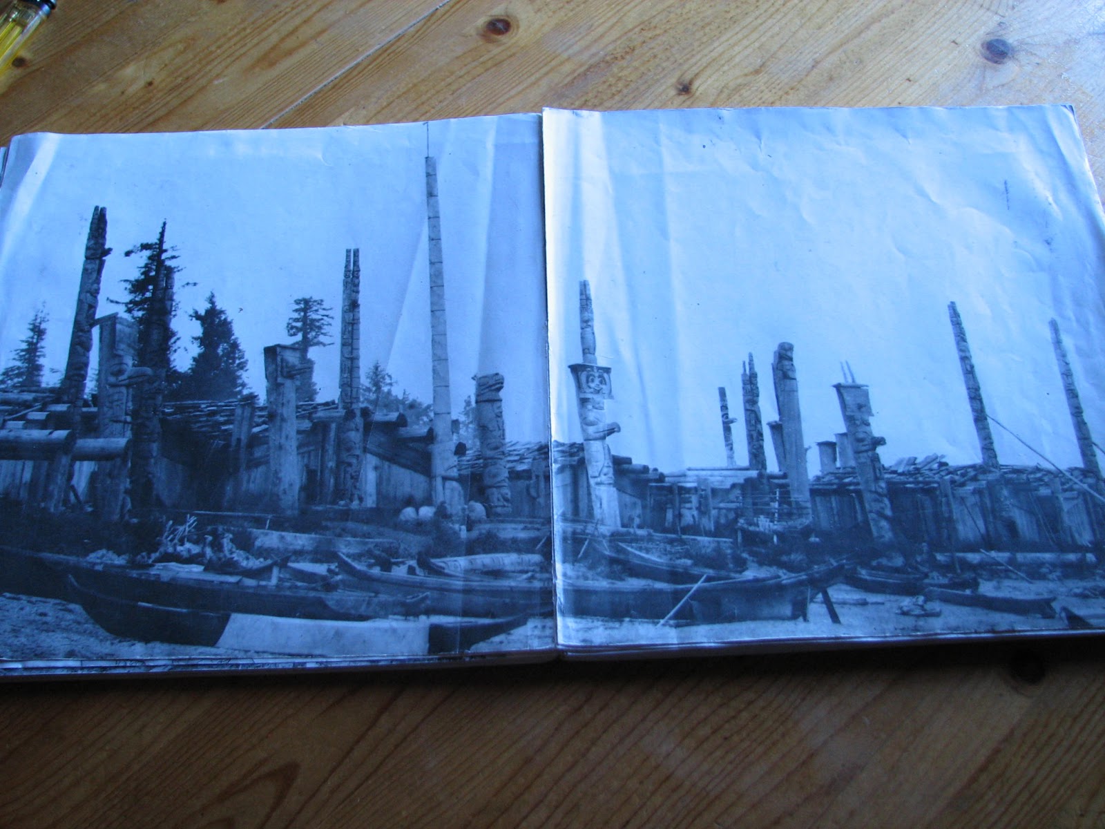
From a book, showing old Tanu ca. 1890

This tree grew up a support beam and the root followed a roof beam.

Watchman Walter, pointing out some details on a Longhouse Foundation
 Walter took us to his cabin, where we met his wife Mary and their granddaughter Raven. Raven is only 8 months old, and apparently takes to men with beards because of an earlier meeting with Santa Claus. So we entertained her a bit with some Ho-Ho-Ho's, and then continued on our tour with Walter around the back side of the old village. Walter does this watchman thing as a way to give back to his Haida Nation, and is retired from some 25 years with the RCMP. By 1730 we were back out to the boat, and under sail past the south side of Tanu Island, and into Richardson Inlet. At the end of the inlet, we followed Richardson Passage, crossing into Echo Harbour, got our anchor down by 1930.....sharing the anchorage this time with another boat - “Berkana”, the Valiant 40 who had crossed Hecate Strait the same day as we had. We had lots of crab in the freezer, so that was an easy dinner decision. For some unknown reason, my Link 20 battery monitor was showing an error, so I disconnected it, after confirming all of our electrics and batteries were still fine.
06 July – This morning we got up again at 0900, had a leisurely breakfast, and then took a row into the lagoon at the south end of the bay. Lots of seals and otters were playing around in the bay and the lagoon, and a pretty little waterfall terminated into the end of the lagoon. We had a pleasant chat with Jim and Barb from “Berkana” who were also rowing around in their dinghy and exploring. By 1100 we had the anchor up, and were underway, and with just the headsail up we tried our hand at trolling. We had partly cloudy skies, a pleasant temperature, and Southeast 15-20 with a 2 foot chop. This was directly opposite to the forecast northwest 20 – we learned later that his entire inside area on the east coast of Moresby tends to come up southeast in late morning, and funnels in the inlets, in spite of whatever the wind is doing a couple of miles east in Hecate Strait. So we had to start motoring again, still trolling. We managed to reel in several nice-looking weeds, but alas – no fish! We pulled into Hoya Pass, into a small bay appropriately named Freshwater Bay. Here the Parks Canada people have put in a float, with a freshwater hose running out to it. We were able to tie onto the float beside Berkana, who'd arrived a few minutes ahead of us, and filled our water tanks with fresh spring water. By 1340 we were underway southbound again, with a strong current and a strong wind against us – so instead of continuing any further we pulled into Koston Inlet, and anchored in the south end at 1600, dropping off our crab traps outside the entrance to the inlet. Berkana had decided to to the same thing, so we invited them over for appies. Barb and Jim rowed over, and we had a very nice chat with them over drinks and appies. We then had a dinner of prawns in a pasta/cheese mix for dinner, and sat back to enjoy the serenity of another beautiful anchorage.
07 July – We had the morning to kill, waiting for a high enough tide to cross the shallow bar at the entrance to the bay, and left on a rising tide at noon. Again, with northwesterly winds forecast, we were getting southeasterlies, so motored across Juan Perez Sound to Hotsprings Island, and tied up to their buoy at 1430. Here we were met by David and Irene, the watchmen we'd earlier met at Skedans....they'd been moved to Hotsprings. David seemed pleased to see us again, and we had a nice visit at their cabin. Then David took us for a walk around the area. There used to be 3 large pools of geothermally heated water here, but the big earthquake of October 2011 shut down the flow into the pools, and they are now dried out memories of the once-popular attraction here. We had a look at the not-so-hot springs, and were shown the gps and satellite relay equipment to monitor for seismic activity. There is still hot water seeping out, but it is not high enough to fill the old pools, and seeps out at a mid-tide level on the beach. We left the mooring buoy here and sailed to Murchison Island, arriving at 1730 (it's the next island to the north of Hotsprings).

David and Ray hiking on Hotsprings (Jade in background)

GPS sensors around the island looking for seismic activity

Solar array and satellite communications for the GPS Sensors

David and Ray inspecting the now dry Not-so-hot-Springs

Watchman's Cabin, Hotsprings Island
 We found the recommended anchorage here too deep to comfortably anchor in, with lots of kelp....so we left, and crossed back over Juan Perez Strait to the bay just south of where we'd spent the last night, entering Sac Bay at 1930. It was a bit late, but we had a tasty dinner of pork chops, and still had time to row to the waterfalls at the head of the inlet to fill up our 5 gallon water tank used for showers.
08 July – We had an earlier morning today, getting up at 0800, and finishing off our older bread by having french toast for breakfast. We had the anchor up by 0920, and tried jigging for fish in the bay, with no success. As we motorsailed eastbound out of Sac Bay, the wind started to pick up from the Southwest....so we were able to get in a very lively sail on a broad to beam reach, passing north of Hotsprings again, entering Faraday Passage, and then turning north for a run to Windy Bay. This is another old Haida Village site with a watchman, and is the location where the Haida and local anti-logging people made a stand against the logging practices in the area, gaining their first real victories toward independent control of the area in the 1980's. This is also the site for the new totem being carved in Skidegate, which we'd earlier viewed at the museum/cultural centre. In Windy Bay we were met by watchman Shawn, who led us on a hike through old-growth forest, pointing out some huge Sitka Spruce trees and Cedars, some of which had been modified by earlier Haida people for bark and planks. Shawn was very knowledgeable about the history of the area and peoples (he has several degrees in anthropology and archaeology), and had a background in the logging industry as well....so he was able to provide us with a lot of stories about the people and the area.

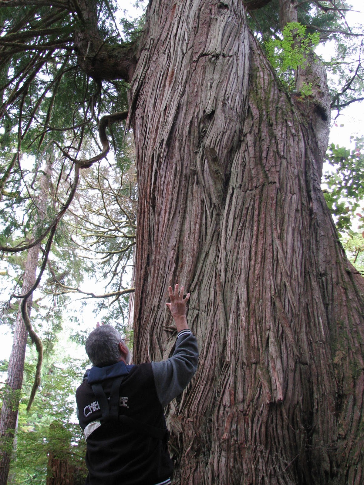
Ray at an old growth Cedar Tree, Windy Bay

Old Growth Spruce

Shawn showing off a modified cedar (where the Haida took cedar bark/planks from a living tree)

Recreation of a Longhouse, in Windy Bay
 By 1545 we'd arrived back at the watchman cabin and met Shawn's wife Helen, and signed the guestbook. We also had a look at a traditional style longhouse built here a few decades ago, and now used as guest quarters for kayakers and other visitors to the site. At 1630 we'd dropped the mooring and had to motor back southbound against the southerly we'd sailed on earlier. But it wasn't far to the little bay 5 miles south, in Ramsay Passage, with 3 convenient mooring buoys for people to wait for Hotsprings (1.25 miles west of the bay). With the winds easing, and clear skies, it was a very beautiful evening in yet another pleasant site. After a bit of stir-fry for dinner, we 
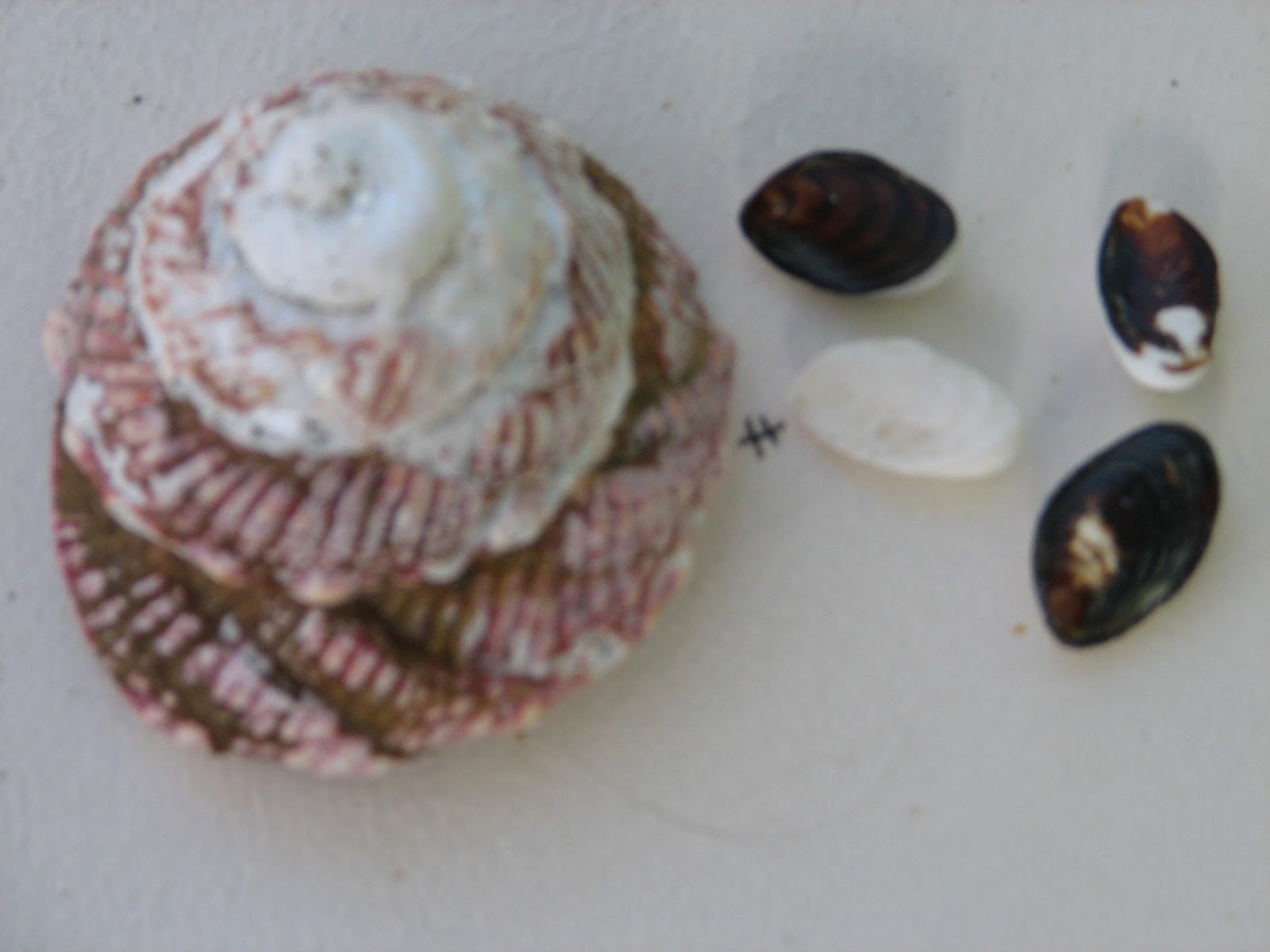
rowed ashore to explore, and to burn our garbage. When we'd visited Hotsprings, David (the watchman) had pointed out the remains of turban snails on the beach, which had been dropped on the rocks by the ravens for the snail meat inside. The snails hang on to a small piece of shell operculum to root themselves in their shells....but after the ravens have had their way, these small pieces lie around on the beach, and are used by the Haida carvers as teeth on their masks, and apparently pay about $1.00 apiece to children to gather them up. We found some of these on the beach here at Ramsay, so collected a few as keepsakes. Back at the boat, we played a bit of cribbage before calling it a night at 2300.

Turban Snail Shell, and 4 "teeth"

Old sea urchin found on beach

Tuesday 09 July – We woke up at 0900 to a nearly windless day, with only a few clouds in the sky. With a forecast for Northwest 10 knots, and our intended course southeast, we pulled out the spinnaker (big, colourful, balloon-shaped sail for downwind sailing) intending to have a bit of fun on a downwind run. But as we motored out of the cove, we were struck by southwest winds of 15 knots, so the spinnaker was out of the question....so we continued motoring out of Ramsay Passage, and stopped to jig for fish on a pinnacle of rock (no fish). The wind then started coming up westerly 20, so we sailed off, trolling all the way to our next anchorage site at Matheson Inlet. We motored into the inlet against strong headwinds and anchored in 40 feet of water, in time for a late lunch at 1430. We then had a bit of time to check out the anchorage, spotting several deer. The wind continued to build to 25-30 knots, gusting....so we let out a lot more anchor rode to improve our holding power. We barbecued some pork chops for dinner and settled down to a rainy night in gale force winds.
Wed 10 July – This ended up being a lay-day for us, with the wind still holding Southwest 25 – 30 and gusting. The entrance to the inlet again has a low bar which requires a rising, higher tide before it's safe to cross out (or in), so we stayed put, working on the Link battery monitor, tracking down a leak on a deck hatch, and reading.
Thurs. 11 July – We got up at 0900, and had the morning to kill before leaving on the rising tide later in the day. So we dinghied ashore for another garbage fire, and to do our laundry in the freshwater creek at the head of the bay. The day had cleared nicely, with only occasional rainshowers passing by, so we raised the anchor at 1400 (tide on the way up, and high enough to get out), and in variable winds had a good sail southbound to Island Bay. On the way in, we'd planned on dropping our prawn traps in Skaat Harbour, but very strong gusty winds prevented our going in there, and we just continued the extra mile to anchor just inside Dolomite Point in Island Bay. This is just north of the entrance to Burnaby Narrows, also called Dolomite Narrows, and is a shallow link of water ( it dries out on a low tide) between Moresby and Burnaby Island. Many boats go the extra 20 miles around Burnaby Island on their way North or South in this area, but many also use the narrows as a shortcut.....which was our plan. We had a breezy, sunny afternoon in our anchorage, so hung out our laundry all over the boat's lifelines, and on makeshift clotheslines, and barbecued some steak for dinner (running low on green veggies, but still had squash and baked potatoes). We watched a black bear scrounging along the shoreline at low tide, munching on crabs and shellfish he found.
Friday 12 July – Today it was up at 0830, have a pancake breakfast, and then launch the dinghy for some serious explorations. We ran the dinghy south through Burnaby Narrows, on a falling and almost low tide, and paying very close attention to the depths, and navigational transits. These transits are privately placed by fishermen or charter groups to guide people through the turns and doglegs in the narrows, and are particularly important to keep from going aground on a passage through the narrows.
When we had noted the locations of the various markers, it was just coming up on low tide....so we explored the passage again, this time northbound. We stopped midway to hike a trail through some old-growth forest, Saw a black bear cruising for food along the shore, admired the masses of sealife on the floor of the passage (starfish of many kinds, sea cucumbers, anemones, crabs, etc), and searched for a rumoured trapper's cabin, which is apparently gone now (at least we couldn't find it!). We were back to our boat at the anchorage at noon, had a light lunch, and by 1430 our laundry was dry, and put away. By 1500 the tide was high enough to venture out to try the narrows in the big boat. We motored through the narrows, with a minimum depth of 8 – 10 feet (we only needed 5.5). Our reconnoiter in the dinghy had paid dividends, as it was clear where and when we needed to make our turns (some of them had to be led a bit due to a bit of current). 

Another gnarly old-growth cedar, on our hike at Burnaby Narrows

This bear was scrounging along the shoreline at Burnaby Narrows

Examining a Cedar with a test-hole drilled into it.
 By 1600 we'd entered a very secure bay/anchorage at the south end of the narrows, at Bag Harbour, anchored in 35 feet, with a good mud bottom to hold us. We celebrated our successful and safe transit with appies and drinks, and sent off our spot message to Linda and Kathy. At 1800 we were having a dinner of Morroccan stew with couscous and freshly baked rolls (managed to bake some fresh bread and rolls during our transit). Another sailboat, “Kinetic”, entered the bay at 1900 and anchored nearby. We 'd seen them earlier at the north end of the narrows, but they'd gone around Burnaby Island instead of transiting the narrows, with some of their crew kayaking through and then meeting the “mother-ship” here in Bag Harbour.
Saturday 13 July – We were up at 0800, had a healthy (I think) breakfast of fruit cocktail, granola, and home-made yoghurt. By 1030 the dinghy was back on deck for a slow troll (motoring slow to charge the batteries) for fish. An hour later we were hailed on the radio by our friends in “Berkana” who saw our sails....and we caught up on our latest news/positions. Just off our destination, Harriett Harbour (where the old mining town of Jedway is located), we caught a dinner-sized rockfish. By 1400 we were anchored in Harriett Harbour in 45 feet of water, with a trip line/buoy to the anchor in case of old mining equipment on the bottom. The abandoned mining town was in its heyday in the early 1900's, and was the site of a sawmill, copper mine, dance hall, hotel, and a fishing fleet....but by 1909 had been abandoned. In 1961 it saw a revival in the form of a company iron mining operation, and boomed for about 6 years....then was abandoned again. Now there are a few old iron pieces of machinery, some slabs of concrete, and a big area of alder trees growing over the site....there are no buildings, and just a bit of a trail, which we hiked. By 1700 we finished exploring the shore and made it back onboard for a meal of fish and yam chips for dinner. We had a relaxing evening reading, and watching a scrounging bear ashore.
Sun 14 July – We were up by 0830, had an omelet for breakfast, cleaned up a bit, and got underway by 1045. We motored out to a rock pinnacle 1.5 miles away, and caught a rockfish on a jig. We continued southeast to another pinnacle, where we caught another rockfish – we had enough for a good dinner now. The overcast skies and rainshowers we'd gotten up to had now cleared up, and we had a nice northwesterly wind of 15-20 knots....so we decided to use the favourable winds to sail the last 20 miles down the east coast to Rose Harbour on the south end of Moresby Island. We had great sailing conditions, sailing at 6-7 knots on a broad reach to a run, then back onto a broad reach. By early afternoon the winds were picking up to 25 knots as we gybed onto a westerly heading into Houston-Stewart Channel, passing a colony of sealions in our wake. 

Sealions in Hecate Strait
 There was a strong counter-current in the channel, but we had lots of wind on the beam to help us drive through it. By 1600 we were off the settlement of Rose Harbour (3 or 4 homes at the site of an old whaling station). There we saw “Berkana” tied to a mooring buoy, another Swiss sailboat tied to a Parks Canada buoy, and “Kinetic” anchored off. We tried our anchor but caught up on kelp, so had to lift the anchor for another go. That's when Jim and Barb on “Berkana” offered to have us raft onto them. They advised that they were on a private mooring buoy, but hat to leave later on, and would be taking up the Parks buoy when the Swiss boat left in a couple of hours, and that we were welcome to join them on a raft-up....something we were happy to do. So rafted up, we had appies and drinks, a rockfish dinner, and a visit with Jim and Barb. This gets the blog to the south end of Gwaii Hanaas, down the east side. I'll get this posted, and continue with the west side on the next entry.
Rafted onto Berkana and Parks mooring buoy, Rose Harbour

Beautiful Downtown Rose Harbour

Sunset over Rose Harbour

Wednesday, July 3, 2013

OOPS! - I Lied!!

Okay...so I said we'd be away from wifi/cell coverage for 3 – 4 weeks. That was the plan.....but here I am, one week later, and I'm blogging from Qn Charlotte again. So here's the last week, with the explanation.
Last Thursday, 27 June, was my last blog entry. That evening, we had the skipper of a local charter sailboat, “Piraeus”, over for some drinks and local knowledge. Billy was happy to oblige, and sails these waters frequently. It was well after midnight before we said goodnight.
Friday, 28 June, I hitchhiked to Skidegate to refill our propane tank, which was about half full, and wouldn't last the full 3 weeks it should. Rennie, a local liveaboard ex-mechanic/fisherman, gave us a 10 lb. Coho salmon and 2 very large crabs (he's very good at catching, and can't eat it all). 

Free Dinners - A Coho and 2 Crabs
We finally left the dock at 1230, bound for Skidegate Channel to the west coast. It is important here to catch the tide just right, as it is quite shallow on lower tides, has strong currents and several S-turns, and the current changes opposite direction in the middle. At 1400 we'd arrived off the east side of the cut – a bit early to start through, so we hove-to (stop the boat by backing the foresail with the mainsail drawing), and waited a half hour. We then transited the narrows just after the start of the last half of a rising tide. By 1630 we'd cleared the narrows and were motor-sailing into Dawson Harbour, about 8 miles west of the west side of the narrows, and at the entrance to the wide-open Pacific. We anchored about 3 miles into the inlet behind a small island, and found a peaceful anchorage. Of course, we had a salmon dinner from the coho given to us earlier. We managed to send out our first “SPOT Message” on our gps messager, to let Linda and Kathy know we were safe and where we were.
Saturday 29 June dawned a misty morning, but clearing. By 0900 we were sailing out of Dawson Harbour in a light southwest breeze, into Cartwright Sound and the open Pacific. There were big patches of kelp everywhere, so our course was quite convoluted as we wove around them on a Northwesterly course, passing between 2 small islands. 

Typical Rugged WestCoast of Haida Gwaii
Winds became light and variable, and we had to start motor-sailing again, staying a few miles offshore, as we could see white foam and breakers on rocks extending from several points of land, some of them extending quite a distance. By 1500 we were off Kindakun Point, which is the southern entrance to Rennell Sound, the largest Sound on Graham Island, and is also an automated weather station. We motorsailed the 10 miles into the Sound, and then turned south, to the end, in Shields Bay. Here we turned in between two small islands to find a beautiful little anchorage. It has no name on the chart, but has been nicknamed “Annie's Cove” by the authors of our Pilot Book. We liked it as well as Annie, for whom they named it. It would be very hard for any appreciable wind to find itself into this spot – we've decided to name it a 5 star anchorage. 

Annie's Cove Anchorage
We had crab for dinner (of course), and over drinks, decided maybe we'd stay another day and have a go at fishing.
Sunday, 30 June, we woke up a bit late (0900), to an overcast sky, with poor visibility in light rain and fog. We raised anchor, and trolled for salmon along the east shore of Shields Bay until we were into Rennell Sound itself – but although we could see the fish on our sounder, none wanted our tasty-looking hoochies. So instead of staying here, we continued out of the sound to check out the next bay to the south – Kano Inlet. By 1600 we were back off Kindakun Point, and crossing into Kano Inlet. There is an island near the entrance, so we anchored inside Cadman Island in Kano, in Carew Bay.  A little bit of swell works itself into this spot, but it was nice, and also close to the outside for an easier departure southbound, in the morning. We barbecued a nice steak with baked potatoes, and called it an early evening.

Carew Bay Anchorage
Monday, 1 July – Happy Canada Day! We were up at 0700 and had the anchor up an hour later. With a sand bottom we decided to try jigging for halibut here, and Ray caught a small one ( a couple of pounds). Our fishing regulations book was non-specific about whether that size may be too small....it just says to check the DFO website for possession limits and sizes. That is a bit impractical for us out here, so we threw the fish back in, and motorsailed out to sea a few miles before turning south in light southwest winds. At 1215 we were off Tcenakum Point, the northwest end of Moresby Island, heading for our first anchorage on the south island. As we manoeuvred around a large kelp patch, we heard a big thump, and discovered we'd just discovered a large, mostly submerged log, which rolled under our keel and then thumped up on our rudder – at this point, we had limited steering, as the rudder post had bent, and I was only able to turn about 10 degrees either way. Using gradual turns, power, sails, and occasional drag in the water, we were able to turn back in toward Skidegate Channel, and eventually were anchoring in Dawson Harbour again. Unfortunately, the anchor was dragging....so we had to motor out to the middle of the bay, and discovered we'd picked up a HUGE amount of kelp and seaweed on the anchor and rode. It took us well over an hour to haul the line with our mainsail winch and cut off the weed, until it was all free. So instead of trying to re-anchor here, we carefully made our way out of Dawson and continued to another bay almost at the west end of Skidegate Channel, Armentieres Inlet. Here we were able to safely anchor. Using our friend Don Logan's technique of tying a clove hitch in the middle of a line, we were able to tie a long line onto the rudder, and led it forward and onto winches.....and then cranked – and cranked – and cranked. The tension created was able to rebend the rudder a little bit – it was now extremely stiff, and certainly not easy steering, but we had almost full turning ability if we used a bit of muscle power. 
 The Video is a short clip of a Lions Mane Jellyfish - common in these anchorages.

So next morning, Tuesday, July 2 (Happy Birthday, Linda!) we were able to get underway and traverse the cut yet again, but this time with limited manoeuvrability. We timed the tides very precisely, and waited in the middle for a short time to get it right. By 1010 we were clearing back into the east side of the channel, and making for Queen Charlotte again – the only possible place we might be able to get some repairs done. We were tied to the docks at 1215, and in no mood for cooking.....so we went to the cafe nearby, Queen B's, for lunch, and then investigated the use of the tide grid (it was available, and no charge!), and to get our tools and lines, equipment, ready for a repair job. There is a machine shop in town with facilities to rebend the shaft, but they advised they were too busy. I was able, though, to rent a chain haul from the tool rental outfit, and decided to have a go at it myself...so booked the grid for the next two days. We had to move the boat onto the grid that night, as the tide was only high enough to get on at 2145. For those of you who don't know what a grid is, it's a framework of posts which allow a boat to drive alongside, and onto wooden supports at high tide, and then wait for the tide to go out to work on the underwater parts of the boat. This we did. By 0500, low tide the next morning, we were able to get out and set up the chain haul with some carpet padding on the rudder and a block and tackle arrangement, and forced the rudder back to its original position. It worked! All bent back nicely, and I was able to epoxy some suspect cracks in the rudder, all before the tide started coming back in at 0830. Nothing we could then do but wait. So we walked to a local restaurant for breakfast, did some laundry, tried a walking tour of the town, and watched a movie about Haida Gwaii at the tourist office. By then it was 1500, with a receding tide again. We were able to clean and fair up the epoxy patches, scrub the water line area of the boat, and tidy up the tools and the boat, before the water started coming back in again.
Jade-1 On the Tide Grid, Qn Charlotte

 This time it is on the way to a higher tide which will lift the boat off the grid, and we can proceed back to the docks with full steering again. I am typing this blog entry following a simple supper of Shepherd's Pie, as we wait for the tide at 2230 tonight so we can do this. The plan is to leave here yet again, and head south to Gwaii Haanas. This time we will be going down the east side of the island, as the forecast winds are for very strong northwesterly conditions for several days – too rough for the west coast, but good for continuing on the east side and then inside. So again, I'm predicting we'll be out of wifi and cellular coverage for 3 – 4 weeks, and if all goes well, this time I'm not lying!

Thursday, June 27, 2013

First Taste of Gwaii Haanas

Friday 21 June – Happy Summer Solstice! It is now time to head south into a bit of Gwaii Haanas, the National Park and Ecological Reserve area co-managed by the Haida Band and Parks Canada, and comprising the southern 2/3 of Moresby Island and surrounding islands. I got up at 0700 and took Jade over to the fuel dock to top up the diesel. At 0900 Ray and Kathy arrived onboard, after checking out of their hotel. It was a misty morning in the “Misty Isles”, with light rain and fog, and very light winds. We motorsailed out across the shallows and turned south, arriving at 1400 off the village of Skedans. Dave and Irene were still there to greet us, and this time Dave took us for a slightly longer tour of the area (he'd known we were planning on the return trip with Kathy). 
Kathy visiting Skedans

At 1600 we started motoring out through the kelp patches when the engine overheat came on again. With kelp patches all around us, and several large rocky areas also nearby, we had to quickly raise the sails and manoevre out while working on clearing the weed clogging the cooling system on the engine. I'm getting fairly proficient at ripping the lines apart and clearing them, and within about 15 minutes we were motorsailing again, in light airs. We continued outside Louise Island and turned in, past the Coast Guard ship “Vector”, to moor up in Thurston Harbour. A book loaned to my by a friend back home in Courtenay lists the names and history of many places in the Queen Charlotte Islands. We learned that Thurston Harbour, even though it now seems so wild and remote, was, in the early 1900's, a thriving town with several sawmills, a dance hall, piers, hotel....etc. Quite a surprise – now it is inhabited by a raccoon, some deer, and bears. We had a nice dinner with scalloped potatoes and ham, and a quiet evening.
The following morning was Saturday 22 June – Ray's birthday! We had a bit of a sleep-in, getting up at 0900 with a big birthday breakfast. Kathy had brought a bunch of cards with her from friends and family to wish Ray birthday greetings, and even a few special treats....a special cigar, and some single malt. We got underway at 1030, with a bit of fishing on a couple of seamounts on the way out, but again the ling cod we caught were too small to keep. We did keep a rock cod, however. 
This Rock Cod was soon to become Cod Balls

 We continued to the west end of Selwyn Inlet, then turned south to pass down Dana Pass into Dana Inlet. We sailed eastbound to the end of this inlet, finally rounding the head at the end of the Tangil Peninsula.....here we were entering Gwaii Haanas. Moderate inflow winds in Logan Inlet gave us a nice broad reach, and by 1700, with the winds easing, we motorsailed the last mile into Anna Inlet....a very pretty little bay with a narrow entrance, and surrounded by snow-capped mountains, and a beautiful grassy estuary at the end. We anchored in 50 feet of water in very good holding bottom of mud, and had our appies of cod balls (the rock cod caught earlier) and cocktails. To celebrate Ray's birthday under warm and sunny skies, we barbecued steak with prawns, and served up birthday cake which Kathy had managed to smuggle aboard. We were able to watch hundreds of squid swimming around our boat....something very new to me. The anchorage is bombproof – very safe – and we again had a peaceful night aboard.
A couple of the many squid which surrounded our boat

Exploring the gnarly woods in Anna Inlet

Ray enjoying his birthday cigar while we burn garbage

 We liked the anchorage so much that we decided to remain here another day, and do a bit of exploring. We launched the dinghy and explored around the edges, walking a short trail at the head of the bay, and observing several otters peeking out at us, and deer lounging in the grass. By 1800 we'd had our daily cocktail hour, had dinner, then went ashore to burn our garbage below the high tide line. Back aboard, we spent the evening playing Hearts until 2300 (Ray and Kathy are quite good at this game!). 
Lots of Squid

Anna Inlet Buck

The following day, Monday 24 June, we arose a bit earlier (0700) because it was now time to start back north, to get Kathy back in time for her flight home. We were underway at 0830, and light winds were again the order of the day. So we were back to motorsailing out Logan Inlet, then back into Selwyn Inlet to turn north in time for a transit of Louise Narrows on a rising tide. We had about a foot higher water than we'd had on our previous transit. Clear of the narrows, we tried trolling for salmon on the way into our anchorage at the west end of Cumshewa Inlet, near Moresby Camp, at Gordon Cove. However, we managed to pick up more weed in our intake, and turned off the engine and were able to sail into the anchorage in light airs, setting the anchor under sail. I was then able to clear the intake again (at least I thought I had it all). I also had to work on our starter becoming intermittent again. The anchor set well, and we had a secure evening, even though there were a few gusty winds blowing into the cove.
Ray and Kathy - lookouts for Louise Narrows

Gordon Cove, in the "Misty Isles"
 Tuesday 25 June – We were up at 0700, prepared for a long day of sailing – the forecast was for Southeast winds of 15-20 knots, building to 25 by afternoon. As we tried to raise the anchor, we discovered we'd caught a cable or piece of equipment on the bottom, and had to use the main halyard winch to haul on the anchor rode, while motoring over the caught area. By 0815 we'd managed to get the anchor up and set out under a single-reefed mainsail to clear out of Cumshewa Inlet which already had 20 knots of wind flowing into it, against us. Again, the engine started overheating , so we were beating back and forth out the inlet with a small jib and reefed mainsail. By the time I'd found the weed clog, we were almost out of the inlet, and the wind had died to almost nothing, leaving a confused “washing machine” effect on the seas. 
We were impressed by this rainbow as we sailed out of Cumshewa Inlet

 At 1130 we were at Cumshewa Islets, turning northbound in Hecate Strait. This is where we'd been hoping for that Southeast 20 knots of wind to give us a sleigh-ride of a sail back to Sandspit. But all we had were calm winds and confused seas....so we motored back, arriving at Sandspit at 1730, and tied up at the marina. A nice dinner of stroganoff and veggies, and with rainy weather outside, we stayed aboard and chatted.
Wednesday 26 June - This is Kathy's departure day to fly back to Vancouver. We moved the boat back to the fuel dock to top up again, and then tied up back on the mooring docks, to clean up, get organized, have showers. Kathy and Ray took a taxi to the airport for her 1520 departure while I got the water tanks refilled, and updated the log, and prepared the blog for our arrival later back at Queen Charlotte, where we'll again have internet and shopping. I've decided to try to get a couple of straight fittings to replace the 90 degree elbows in my cooling system, as this seems to be a weed magnet. This area is known for its prolific biomass....and that includes lots of weed in the water, so I'll need to fix the way our intake works, or I'll be spending every day ripping it apart to clean out the weeds. We'll spend a day restocking the larder, cleaning the laundry, and then set out back into Gwaii Haanas for a more complete exploration of several weeks. The sail across from Sandspit to Qn Charlotte was a very nice broad reach, and by 1700 we were tucked into the docks at our normal space....it feels almost like home now, as when we arrived, several of the other boaters, who now know us, stopped over to say hello and to trade stories of where we'd been and what were our plans. Apparently we'd missed the end of the Stanley Cup Finals – so no hockey – but we went to Howlers Pub (the only pub in town) for dinner and a beer, and were greeted by Rose, the waitress, who immediately plunked down our normal beer order. We hadn't worked very hard during the day, but were still tired, and were in bed by 2200.
It is now Thursday 27 June. Our projects are pretty much complete – Ray has restocked the boat with groceries, restocked the bar, completed the laundry. I've rebuilt the intake hoses and eliminated the elbows, replaced an “iffy” alternator belt, changed the engine oil, and tidied up the boat. Ray has now successfully initialized the “Spot”, a GPS short-message system which allows for satellite communications (very short messages, like “We've arrived, and we're OK”, or....”We're stuck in....for awhile”, etc...). When we leave on the flood tide tomorrow, we'll be out of cell-phone and wifi contact for about 4 weeks. We plan on heading to the West Coast of the islands if the weather forecast continues to favour it. If the weather looks iffy, we'll go down the east coast, and then come back up the west side to return here via the cut between Moresby and Graham Islands, in about 4 weeks.